Saturday, August 31, 2013

Colca Canyon (August 22nd - 26th, 2013)

Colca Canyon is the second deepest canyon in the world. We were really looking forward to going there, as it has a good hiking infrastructure and for once we could leave our camping equipment at the storage of our hostel. 

We arrived at the bus terminal quite a lot in advance, as we had been advised at an information point. To our surprise, at the bus terminal, we were told that there is a bus that leaves for Chivay immediately, and that there is no direct connection to Cabanaconde on that day. Happy that we did not have to wait, we took the bus and arrived in Chivay. There we found out that the next bus to Cabanaconde would leave 90 minutes later, so we walked to the central square and had a late lunch. In the evening we arrived in Cabanaconde. We were thinking of staying at Pachamamahome and we were delighted to find that there was a person waiting at the square to bring other people from the bus to the hostel. We happily joined him and got one of the last free rooms there. In the evening we had a pizza, took advantage of the happy hour and played a game of chess, which Laura won again.

In the morning I biked up to Cruz del Condor, which was indeed quite tough. Laura, together with Nicole from the US and Anna from Spain took a luxurious option to be driven there by the owner of our hostel. We spent almost two hours watching the condors. At around 10 a.m. the condors were really flying five meters away from us and we truly enjoyed a close view of these magnificent birds.

One of many condors we saw

From Cruz del Condor we biked all together back to Cabanaconde. It took us a bit more time than expected. Laura and I then had a quick lunch and started descending to the bottom of the canyon. It was a long way down, but provided us with many marvelous views.

A long way down to the bottom of the Colca Canyon

A bridge and geysers at the bottom

Fortunately, our schematic map from Pachamamahome was a bit wrong and from the bridge we managed to go to Llahuar in 40 minutes instead of the suggested 2 hours. At Llahuar we had plenty of time to enjoy a thermal pool together with a nice German group. After the pool we were hungry and had a delicious vegetarian dinner. We planned our next day, and soon it was time to go to sleep in our small bungalow.

The cutest guest of Llahuar lodge

The next day we hiked up on the road towards Mallata. The views were again great, but eventually the weather started getting a bit worse. We even put the rain covers on our back, but fortunately we did not really need them.

Beautiful river down in the valley

In the morning the weather was still good

In Mallata we were planning to have lunch at a local restaurant. This plan was changed because of a supply truck that attracted everybody's attention, including that of the restaurant owner. We adapted quickly and also bought some supplies for our lunch from the truck.

Truck providing bread, fruits, rice, pasta and other supplies
From Mallata it was an easy hike down to Oasis Sangalle. It again started to look a bit like rain, so we needed to hurry.

Going down was straightforward

Laura with a waterfall close to our lodge

We were positively surprised with the accommodation in Oasis Sangalle: competition can do miracles. Every place had a pool and a beautiful garden. We even had a volleyball court. As the weather got a bit better we swam in the pool and then relaxed in the hammocks. After dinner we played cards with two nice people from the UK/Ireland.

Pool at our lodge, not as warm as the thermal baths at Llahuar, but still pleasant for swimming

By the time we woke up the next day, everybody else had already left. We did not know that the sun may make the ascent to Cabanaconde quite unpleasant and that all groups try to make it there at 9 or earlier. Fortunately, it was not a problem for us as it was quite cloudy. On the way up, we enjoyed the best views of the canyon.

Morning at our lodge

Our place from above

Colca Canyon is surrounded by some quite high mountains
Around noon we managed to reach Cabanaconde. We soon found out that the 2 p.m. bus was completely sold out, so we quickly joined some other tourists who had already managed to organize a big taxi to Chivay. There we had a late lunch and then relaxed in the local thermal baths. The next morning we took a bus back to Arequipa.

As usually, we contributed to OpenStreetMap and have some more pictures.

Puno and its surroundings (August 13th - 18th, 2013)

Our two-and-a-half-month-long stay in Bolivia came to an end soon after we had departed from Copacabana. We didn't spend much time at the border: this was the first time in South America when my Estonian passport was not subjected to extreme scrutiny. In fact, the lady working at the Peruvian border was on the phone while stamping the passports and didn't seem to be too bothered by us. Thus, we said good-bye to Bolivia and hello to Peru! 

Hello, Peru!

A couple of hours later, we arrived in Puno, which is located at Lake Titicaca, similarly to Copacabana. The first thing we noticed was the taxi driver putting on his seat belt. The only time we saw people using their seat belts in Bolivia was when our friends Cynthia and Gonzalo drove us around in Santa Cruz. Since that taxi ride, though, we've often seen the Peruvian drivers put on their seat belt only when they've spotted police officers.

Still recovering from stomach problems, we took the first couple of days in Peru very easy. We wanted to visit the nearby islands, and decided to go on a two-day tour with All Ways Travel, and were especially looking forward to meeting a Peruvian family through homestay on Amantani island.

The trip involved several sunny and nice boat rides on Lake Titicaca. On the first day, we visited the floating Uros islands. For the past several hundred years, the Uru people have created their own islands out of reeds, and they continue to do so nowadays. They use reeds for just about everything else as well: to build houses and boats; they even eat these plants. A lady named Olga showed us her house and asked us to dress up in the local clothes. Afterwards, she and her family started to pressure us to buy souvenirs, and we felt rather uncomfortable. This was the first time that we sensed that Peru is far more touristy than Bolivia, perhaps even too touristy.

One of the more than 40 floating reed islands, with reed houses and reed boats

Together with Olga on a floating island

We then went to Amantani, the largest island on the Peruvian side of Lake Titicaca. Here, our group was split up, so that up to four people would stay with individual families of the island. Radek and I were teamed up with an Italian couple - Simone and Stefania. While our host lead us to his house, we had a chance to talk to him a bit. Sadly, this turned out to be the only time we would talk with him - the family practically ignored us during our stay, and their home was much rather like a basic hotel. All four of us were very disappointed, because we had really wanted to meet a local family. Fortunately, the other people on the tour had a much better experience: they would talk with the families, help them cook, etc.

Despite the rather unhappy encounter with our host family, we still enjoyed the beauty of the island. We, along with about a hundred other people, walked to its highest point and watched the sunset.  It was absolutely magnificent, perhaps just slightly tainted by people always trying to sell something to us.

Going, going, gone!

Later in the evening, we again dressed up in traditional clothing (very different from the ones on Uros islands). We then went to a party where we danced to the local music.

Getting ready to dance

The next morning we went to Taquile island. Here, walked across the island, and had great views of the lake. We also learned about the islanders' amazing weaving culture (both men and women weave there, and they are apparently world-famous for it), and had a delicious trout for lunch.

Taquile landscape with terraces

The lake seemed endless

Our guide (right) with a man from Taquile showing us his weaving skills (left)

On the long boat rides, we made some friends - Lorena and Salvador from Spain - and decided to meet them for dinner. This was our first time to try ceviche, a sour and spicy marinated fish dish. The company was great and the food delicious! Perhaps it was not such a wise idea to eat raw fish after being sick, though: the next day, I was again not feeling very well. Radek alone went to see the Coca museum, but was not very impressed by it.

During our last day in Puno, we visited the oldest steamship on Lake Titicaca, the Yavari. She was built in 1862 in Birmingham and then shipped in parts around South America to Arica, from where it took five years to move it by train and mule over the Andes to Puno. Due to a shortage of coal, it was for long fueled with llama dung, but now runs on diesel. The ship has been nicely restored and is currently a B&B.

The Yavari steamship

After seeing the ship, we took a bus west to Arequipa.

More photos of Puno and the Lake Titicaca islands can be seen here.

Tuesday, August 27, 2013

Copacabana and its surroundings (August 11th - 13th, 2013)

Copacabana is the main hub for visiting Lake Titicaca from Bolivia. It is a small town with the only public beach in Bolivia and many cheap, but good hotels.

I had a bit of a stomach ache in the morning when we boarded the bus, so I was happily surprised by its quality, as it even had a toilet and free Wi-Fi. Copacabana is on a peninsula that is connected with Peru, but not with the rest of Bolivia. Because of this, we and our bus had to take a boat to get there. This was actually a very nice reason to stop, and it gave us the first close look of the lake.

One of the many ways how Bolivia shows its unhappiness about losing access to the sea

After arrival I was very happy about our spacious room with a great view of the beach. As I was still a bit under the weather, I was glad I could lie down.

View from our room

After a bit of rest, we went for a short walk on the beach. The beach was not appetizing at all, as it was filled with trash and smelled bad. What was more interesting was a special celebration that people had for their cars. They decorated them in a very colorful way and then asked a shaman to perform a ceremony, so they would not have any accidents in the next year.

One of the many decorated cars

Laura went to eat trout in one of the restaurants recommended in Lonely Planet, but she came back very unhappy. She told me that the fish tasted like mud. Fortunately, the marvelous sunset from the balcony of our hotel compensated for any bad experiences of the day.

Isn't this spectacular?

On the following day I was feeling much better. Breakfast at our hostel was one big chaos and many items, such as hot water or bread were missing. We ate what we could and hurried to the port to catch a boat to Isla del Sol, which is the biggest island of Lake Titicaca. The boat took us to the northern port.

Northern port of Isla del Sol

Pigs seemed to be common inhabitants of this beach

It took us a bit of time to orientate ourselves, but soon we were on the right track with tons of other tourists. The views were magnificent. We joined one guide who told us about different ruins in the northern part of the island. He also gave us some sacred water from a well at Chincana.

Mesa Ritual

From there we continued independently over the ridge of the island. We had wonderful views in all directions, including views of Illampu, a mountain in the Cordillera Real we did not have a chance to visit. We were a bit surprised that in total we were asked three times to pay a fee for passing through village territories. Fortunately, the fees were acceptable, but we still did not understand why one village would charge manyfold more than another.

Laura and one of the gates where we had to pay an entrance fee

Eventually we arrived in Yumani. We had a late lunch there and took a boat back to Copacabana. In the evening we climbed Cerro Calvario. The sunset from there was not as good as from our hotel, and considering the amount of trash lying all around, it was really not worth the climb up. Fortunately, the bad impression from the hill was somewhat reduced at its foot. Here, we went to the La Cúpola restaurant and enjoyed an excellent cheese fondue.

Copacabana in the evening light

The next morning it was Laura's turn to feel a bit sick, so I went to visit the cathedral in the center on my own. We then bought bus tickets to Puno, had lunch and said our good-byes to Bolivia.

One of the last pictures we made in Bolivia

We really enjoyed Bolivia, but as we stayed here for two and half months, it was time to move on. Thus, our next post will be about Peru. As usually, we have some more pictures.

Nuestra Señora de La Paz (July 10th - 17th and July 30th - August 11th, 2013)

We took a night bus from Cochabamba and early the next morning, we arrived in La Paz, the de facto capital of Bolivia. Once we arrived at our hostel, we were surprised to see our hiking buddy Dan there. Dan's friend Jaime was visiting him, and we ended up spending the morning together. We had an excellent pancake breakfast at the hostel, and then wandered around the witches' market. Apparently, it is impossible to construct a building without first getting some supplies from here. For example, a llama fetus bought from the market would be put into the foundation of the building as an offering to Pachamama, and no builder would work for you without first seeing this ceremony.

Llama fetuses and baby llamas at the witches' market

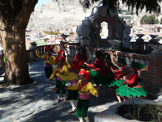
After walking for about an hour, Dan and Jaime decided to go to a cafe where they could catch up on some work (both were working during their travels), and Radek and I continued to a couple of viewpoints. Going uphill at such an altitude - at approx. 3650 m - was quite demanding, but well worth it. The views were absolutely beautiful. We also saw a group of people being filmed while dancing some traditional dances.

Aview of La Paz and Illimani

A snapshot of a traditional dance

While walking around, we noticed some people dressed up as zebras, teaching drivers how to behave at pedestrian crossings. Apparently, they have been at it for years already, but their efforts have been quite fruitless: pedestrians never have the right of way in La Paz.

We hope that he is not another Sisyphus

During the following week, we went on several trips: we saw the Tiwanaku ruins, hiked near the magnificent Illimani mountain, and Radek raced down the Death Road. We then wanted to go on some more hikes near La Paz, but the weather turned for the worse, so we decided to go to the jungle town of Rurrenabaque instead. Though it was a bit cold there as well for some days, we had a nice time in the pampas and jungle near Rurre, and returned to La Paz at the end of July.

We love to go on free walking tours, or to be more precise, ones that are based on tips, because the guides are usually very nice and motivated. During our trip to Tiwanaku, Christy recommended the Red Cap Walking tour in La Paz, and we were really glad that she did. The tour was an absolute delight! Among other things, our guides recommended that we try Pollos Copacabana, a La Paz-based fast food chain that was indeed very good. It is and has been so popular that it probably contributed to McDonald's going bankrupt in Bolivia (one of the very few countries where that has ever happened). On the tour, we met a nice Danish couple, and decided to have lunch together. Afterwards, we enjoyed some excellent mixed juices at the Mercado Lanza.

Radek's juice was called "Supervitaminico"

The next day, we left for a hike on the Choro trail, and returned three days later. During our resting day, we went to four small museums on the old and beautiful Calle Jaén. The Museum of Folklore had about a dozen miniature scenes of different ages in Bolivia; the Litoral Museum is about the Pacific War, lost to Chile in the end of the 19th century; Casa Murillo was the home of one of Bolivia's most famous freedom fighters - Don Pedro Domingo Murillo. Perhaps the most interesting of the museums was the Museum of Precious Metals, or the Museum of Gold, which displays a myriad of gold and silver workings from the Tiwanaku and Inca cultures.

Radek on the old colonial street Calle Jaén, waiting for the museums to open

Soon afterwards, we departed for another hike in the Cordillera Real, this time in the Condoriri area. Upon our return, we visited the San Fransisco Basilica. This church was built in the former indiginous section of La Paz, with the Spanish district on the other side of the Choqueyapu River (now paved over). Its facade has some interesting mestizo influences, including carvings of vomiting men. This must have been what the locals viewed the Spanish - it was the Spanish that brought the catholic church and the art of liquor production to the area. The tour of the church and associated convent was really not that great, but we loved the view from the roof of the church. 

I'm never going to drink again!

San Fransisco Basilica

A view of the Lanza market from the roof of the San Franscisco Basilica 

The day after visiting the San Fransisco church, we headed for Lake Titicaca, the highest navigable lake in the world.

A gallery with more photos of La Paz can be seen here.

Wednesday, August 21, 2013

Condoriri (August 5th - 8th, 2013)

We planned this hike as a potential acclimatization trip for Huyana Potosi. It was our second hike in the Cordillera Real.

As usually, we started our trip at Adolfo's office. We were quite happy that we met him through our Illimani trek, because in contrast to all other agencies we visited, he was the only one capable and willing to give us information for independent trekking. He told us that he may have a group that we could share transportation with the next day, so we booked a car with him. The group did not show up, so the next day we got a private "taxi". Already from the road we had gorgeous views of the Cordillera Real.

Almost the whole Cordillera Real far in the background

Approaching Condoriri

Our driver smoothly delivered us to a small settlement that was one hour away from the Condoriri base camp. We ate our lunch, which we bought from a stand at El Alto that our driver had recommended, but it was quite bad, so we gave half of it to a local dog. From this settlement it was an easy hike to the base camp. There, we set up our tent and went for a short acclimatization hike.

Laura getting ready

From base camp it was an easy 40 minutes walk to the beginning of the glacier on Pequeño Alpamayo. We hiked there and back, cooked, observed some viscachas, and then it was already time to go to sleep.

From here on you need crampons!

Glacier on Pequeño Alpamayo

The next morning we took it easy, as our only plan was a five hour hike to the top of Pico Austria. We departed at around 10 a.m., as the majority of the morning we had to spent on boiling water: our SteriPEN batteries had just ran out without giving us the warning specified in the manual.

Morning at the base camp

In the beginning it took us a while to find the path. Laura was not feeling very well and without the path she was unable to find a good walking and breathing rhythm. We knew that a path should exist and which direction it should go, but it still took us a while to find it. After finding the path, Laura immediately got happier and we continued at a speed appropriate for that altitude. With a couple of short breaks on the way, we made it to a pass. We had our lunch there and enjoyed the amazing views.

The small lake we discovered behind the pass

One of the many amazing views

From the pass it was just straight up. I also started feeling the altitude and was very happy with Laura's pace. At 1 a.m. we made it to the top of Pico Austria, setting our new altitude record. Unfortunately, various sources can not agree on the exact altitude. I have seen numbers from 5270m to 5400m, but we decided to call it 5350m, which is the value from OpenStreetMap and matched the data from our GPS quite well. On the top, it was even possible to see the Lake Titicaca, but we did not manage to make any good pictures of it.

The summit photo

Our base camp is down there

The way down was easy and straightforward, but still filled with gorgeous views. We were at the camp at around 4 p.m., and spent the whole afternoon cooking and boiling water for the following day.

In the morning, we packed and dried our tents, and once again departed at around 10 a.m.

Packing in the morning

Similarly to the previous day, finding the path was not easy. Eventually we made it to the place marked on our GPS, but there was still no path. We continued and after some more hiking the path started to be recognizable. Unfortunately Laura was not feeling well: her stomach was gave her some trouble, and she was short on breath. Taking as much as possible out of her bag helped a bit, but we were still quite slow.

Tired pile of unhappiness (direct translation from both Estonian and Czech)

Around noon we made it to the first pass and Laura started feeling bit better on the way down. We also had a small lunch, but did not want to waste too much time: the weather was getting suspicious, with some not-so-distant thunder. We lost our path and had to find it again, which delayed us a bit, but eventually, we made it to the start of the second ascent. As I was carrying the majority of the weight, my speed slowed down considerably as well, but eventually we made it to the top. From there we knew that we would only need to go down.

Suspicious weather

The descent was long but nice. We moved our rain jackets to the top of the backpacks to have them ready, but luckily, we did not need to use them. On the way we also met some llamas and made a stop at a dam.

Llamas

This dam powers a hydroelectric power plant way down below

At around 6 p.m. we made it down to Chaca Pampa. As chances of getting transportation back to La Paz at that hour were nonexistent, we talked to the power plant workers about possibilities of spending the night in the town. One of them was able to get us a place to stay in the building next to the church, free of charge. We were very happy about that, because just then, the storm caught up with us.

Our last camping spot

The next day we went to the local bus stop, and got a ride to El Alto. The ride went around Huyana Potosi and provided us with many wonderful views. Unfortunately, as Laura was feeling bad during this hike, she decided that there is no way she would even try to climb it.

Huyana Potosi next morning

As usually, we contributed to OpenStreetMap and have more pictures.